عقابکوه(About Eagle Mountain )
درباره عقابکوه(About Eagle Mountain )عقابکوه(About Eagle Mountain )
درباره عقابکوه(About Eagle Mountain )آشنایی با عقابکوه یزدGetting to know the Yazd mountain eagle
آشنایی با عقابکوه یزد
Getting to know the Yazd mountain eagle
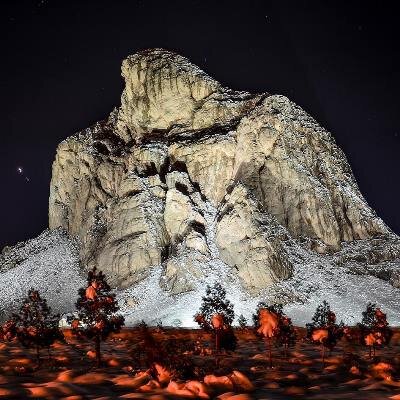
«عقابکوه» یکی از جالبترین و دیدنیترین کوههای استان یزد است که در شهرستان تفت قرار دارد.

همشهریآنلاین: عقابکوه به صورت یک کوه نسبتا بلند حدود دو هزار متر از سطح دریا ارتفاع دارد. تنها بودن این کوه و زیبایی خیرهکنندهاش همانند یک عقاب در دل کویر، نشان از پادشاهی این کوه در منطقه دارد.
عقابکوه یزد در نزدیکی روستای فراشاه یا اسلامیه واقع شده و منظر طبیعی این کوه به شماره ۳۴۷ در فهرست آثار ملی ایران به ثبت رسیدهاست.
روستای فراشاه که در امتداد محور یزد ـ شیراز و ۳۰ کیلومتری جنوب غربی مرکز استان و ۱۰ کیلومتری شهرستان تفت قرار دارد، از شمال به کوه انجیرایی، از جنوب به کوه سهراب و شیرکوه، از شرق به کوه گلوبادام و از غرب به عقابکوه متصل است.
ارتفاع این روستا از سطح دریا هزار و ۷۶۰ متر است و به دلیل رودخانه فیضآباد که از کنار آبادی میگذرد، آبوهوای آن در فصلهای بهار و پاییز معتدل، در تابستان نسبتاً گرم و در زمستان سرد است.
صعود به قله
قله زیبای عقابکوه در ارتفاع ۱۴۰ متری از سطح روستای فراشاه قرار دارد. برای صعود به قله باید با طی ۱۰ کیلومتر از تفت به سمت این روستا رفت. پس از رسیدن به فراشاه، باید از قسمت غربی روستا به سمت دامنه شمال غربی عقابکوه که شیب کمتری دارد، حرکت کرد .
قدمت عقابکوه را به اوایل دوره دوم زمینشناسی نسبت دادهاند. در اواخر دوره دوم، ساختار بخشهای دیگر کوه تغییر کرد و ارتفاع بیشتری به خود گرفت. در دوره چهارم زمینشناسی، بافت آهکی عقاب کوه یزد به خاطر افت دما، یخ بندان شدید و سپس ذوب شدن آن، به شدت دچار فرسایش شیمیایی و مکانیکی شد.
فرسایش کوه
متفاوت بودن جنس سنگهای اطراف کوه و فرآیندهای فرسایشی آبی و بادی باعث تشکیل عقابکوه شده است. کوههای بلند انجیرایی، سهراب و شیرکوه که اطراف این کوه را گرفتهاند، یک تونل باد را به وجود آوردهاند که همراه باد و باران باعث ایجاد این شکل دیدنی شدهاند.
به علت فرسایش و آهکی بودن جنس کوه، هیچ گیاه و چشمهای بر روی آن وجود ندارد. حفرههای بسیاری در قسمت فوقانی به چشم میخورد که جانوران از آن به عنوان لانه استفاده میکنند.
توده گرانیتی در غرب عقابکوه، این تشکیلات آهکی را به سمت بالا آورده و حتی باعث دگرگونی بعضی قسمتهای زیرین کوه نیز شده است.
خطرات طبیعی و انسانی
فرسایش همانطور که موجب شکلگیری چنین جاذبهای شده، در حال حاضر نیز به آن صدمه وارد کرده است. وجود سنگها و حفرههای بزرگ و کوچک که در دامنه کوه هستند، نشان از همین فرسایش دارد.
بومیان معتقدند که بدنه عقابکوه در طی سالهای اخیر دچار تغییر و تکههایی از آن نیز جدا شدهاست.
Acquaintance with Eagle Mountain, Yazd Getting to know the Yazd mountain eagle "Eagle Mountain" is one of the most interesting and spectacular mountains in Yazd province, located in Taft city. mountain eagle Hamshahri Online: Aqabkoh is a relatively high mountain about two thousand meters above sea level. The solitude of this mountain and its stunning beauty, like an eagle in the heart of the desert, shows the kingship of this mountain in the region. Eagle Mountain of Yazd is located near the village of Farashah or Islamia and the natural landscape of this mountain is registered as number 347 in the list of national monuments of Iran. Farashah village, which is located along the Yazd-Shiraz axis and 30 kilometers southwest of the provincial capital and 10 kilometers from Taft city, is connected to Anjirai mountain from the north, Sohrab and Shirkoh mountains from the south, Globadam mountain from the east, and Aqab mountain from the west. . The height of this village is 1,760 meters above sea level, and because of the Faizabad River that passes by the village, its weather is mild in spring and autumn, relatively hot in summer and cold in winter. Climb to peak The beautiful peak of Aqabkoh is located at a height of 140 meters above the level of Farashah village. To climb to the peak, you have to walk 10 kilometers from Taft to this village. After reaching Farshah, one should move from the western part of the village to the northwestern slope of Aqabkoh, which has a lower slope. The age of Eagle Mountain has been attributed to the beginning of the second geological period. At the end of the second period, the structure of other parts of the mountain changed and gained more height. In the fourth geological period, the calcareous texture of Yazd Mountain Eagle suffered severe chemical and mechanical erosion due to temperature drop, severe freezing and then melting. Mountain erosion Different types of rocks around the mountain and water and wind erosion processes have caused the formation of Eagle Mountain. The high mountains of Anjirai, Sohrab and Shirkoh, which surround this mountain, have created a wind tunnel, which together with the wind and rain have created this spectacular shape. Due to the erosion and limestone nature of the mountain, there are no plants or springs on it. Many holes can be seen in the upper part, which animals use as nests. The granite mass in the west of Aqab Kouh has brought this limestone formation upwards and has even caused the transformation of some lower parts of the mountain. Natural and human hazards Erosion, just as it caused the formation of such an attraction, has also harmed it now. The presence of small and large rocks and holes on the mountain slopes is a sign of this erosion. The natives believe that the body of Eagle Mountain has undergone changes in recent years and pieces have been separated from it.